


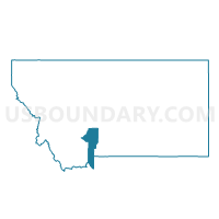
Precinct 18, Gallatin County, Montana
About
Outline

Summary
| Unique Area Identifier | 612014 |
| Name | Precinct 18 |
| County | Gallatin County |
| State | Montana |
| Area (square miles) | 10.77 |
| Land Area (square miles) | 10.70 |
| Water Area (square miles) | 0.07 |
| % of Land Area | 99.36 |
| % of Water Area | 0.64 |
| Latitude of the Internal Point | 45.76426680 |
| Longtitude of the Internal Point | -111.11681490 |
Maps


Graphs
Select a template below for downloading or customizing gragh for Precinct 18, Gallatin County, Montana


Neighbors
Neighoring Voting District (by Name) Neighboring Voting District on the Map
- Precinct 17, Gallatin County, MT
- Precinct 19, Gallatin County, MT
- Precinct 29, Gallatin County, MT
- Precinct 31, Gallatin County, MT